Previous year's Nominees

A view on the model and tools for Km4City. http://www.disit.org/km4city, http://servicemap.disit.org
A very large number of public and private data sets are available from local governments and are a huge resources for Europe and for the cities. In most cases, the citizens use worldwide operators such as Google, OpenStreet Map, Here, TomTom, etc., to get information while they found it in most cases insufficient for who is leaving in the city. The local governs have much more detailed data, some of them are public other are private and accessible only as authenticated services and thus not easily accessible for worldwide operators. These open and private valuable data are present at level of city, region or at national level. Unfortunately, they are too fragmented and not accessible for the final users, citizens or companies that use to exploit them for providing services. They could be a source of revenues and are becoming a big business for local specific services, too small and complex to be of interest for worldwide operators.
In most cases, the above mentioned local private and open data are not semantically interoperable and a huge effort would be needed to create applications and services that provide them in aggregated manner. They could be used for providing integrated services in multiple domains to citizens integrating aspects of mobility and transport, with energy, banks, parking, commercial, bike paths, delay for busses, garden areas, etc.
The solution is covering multiple domains for citizens integrating aspects of mobility and transport, with energy, banks, parking, commercial, bike paths, delay for busses, garden areas, etc .
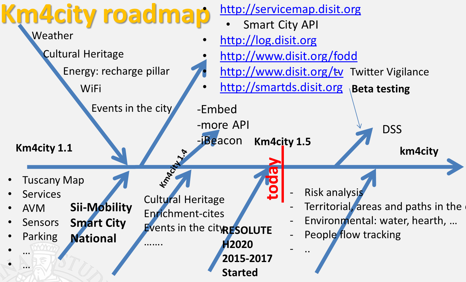
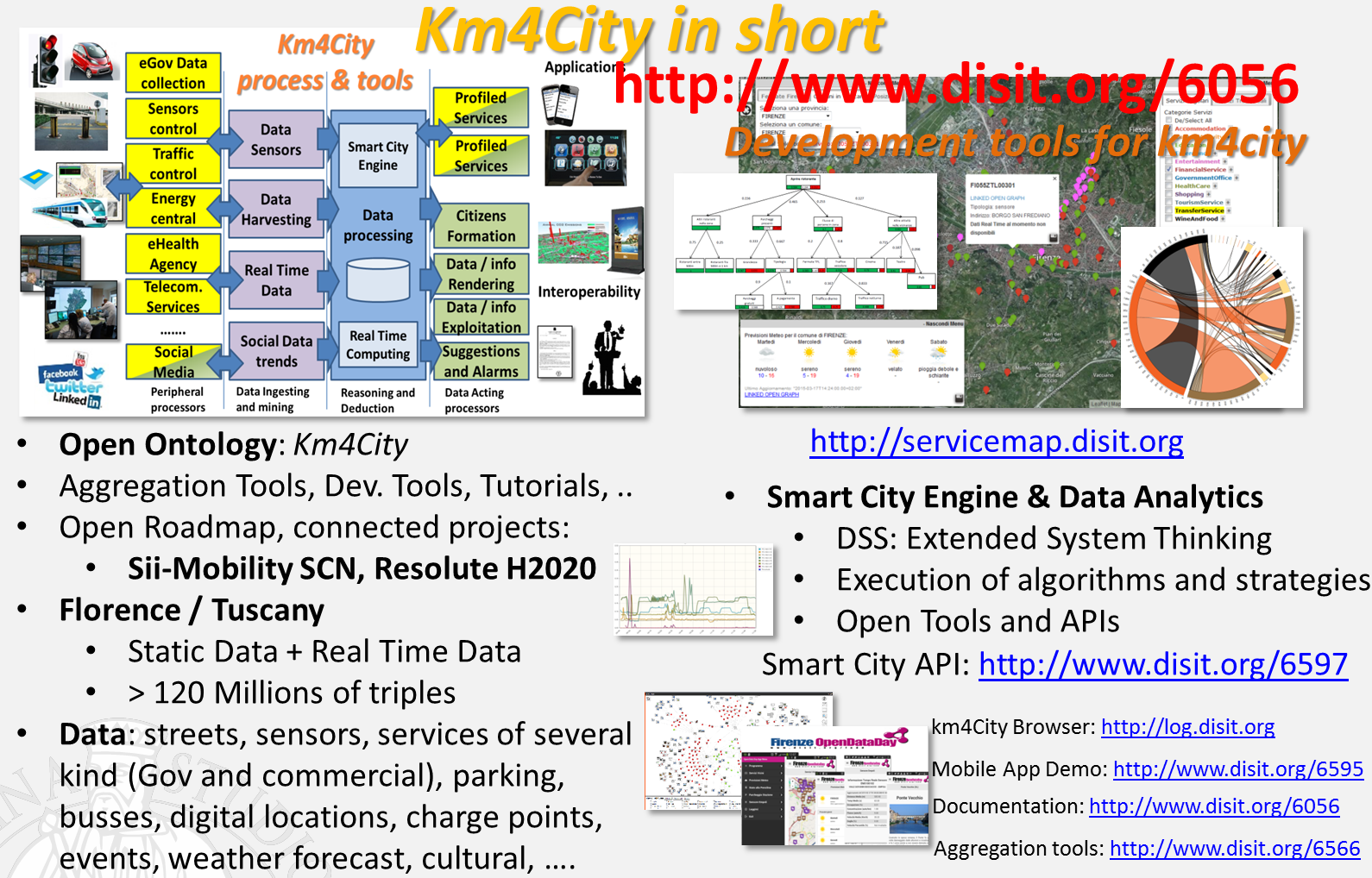
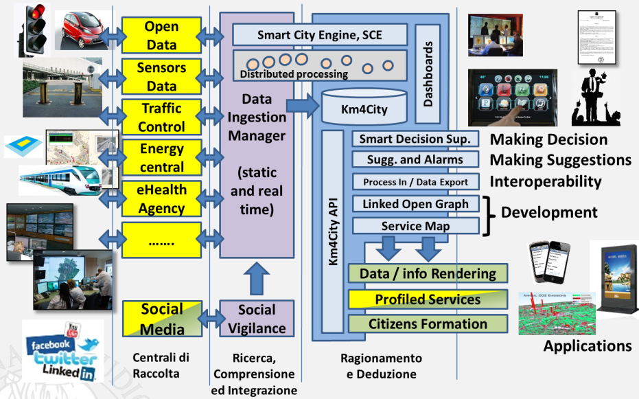
In order to solve the above described problems and provide a unique point of access for interoperable data of a city metropolitan area we have realized (http://www.disit.org/km4city ) an ontological model called Km4City and well formalized and open grounded on ontology standards. In addition, a set of tools for data ingestion, management, aggregation, indexing and for producing in short time web and mobile applications have been realized and make accessible. The solution is presently today in place in Florence and whole Tuscany area. A smarter navigation can be performed from http://servemap.disit.org while mobile applications are accessible on Google Play and Apple Store.
As regarding the Km4City model:
• documentation: http://www.disit.org/5606 of the km4city ontology
• Schema according to W3C http://www.disit.org/km4city/schema
• RDF end point http://log.disit.org/spqlquery/
And a set of tools for developers:
• Ingesting data, making them interoperable, and accessible via a Linked Open Data, RDF end point, via a scalable ingestion process and tools, to be used by cities that could be interested in setting up new Km4City installations. The solution provide open tools and methods for data ingestion and reconciliation of smart cities related aspects as road graph, services available on the roads, traffic sensors etc.,
o SLIDE: http://www.disit.org/6669
o RIM: RDF Index Manager: user manual, for versioning of graph databases RDF stores.
o DIM: Data Ingestion Manager: http://www.disit.org/6732
• ServiceMap Development tool based on visual query: http://servicemap.disit.org that allows to visually create the queries that can be used to access at integrated semantic data even without learning a SPARQL. The ServiceMap Development tool send query ID or SPARQL queries via email that can be easily exploited for realizing web and mobile applications in short time.
o http://servicemap.disit.org development tool for visual queries and LD analysis
o http://log.disit.org linked open graph for RDF store, Linked data, LOD navigation
• Smart city KM4city API for developers:
o http://www.disit.org/6597
• Smart decision system tool for city administrators: http://smartds.disit.org based on system thinking.
And a set of tools for Final users:
• Exploiting city model and data from web application:
o http://www.km4city.org web application
• Exploiting city model and data from mobile applications on Android, iOS
o Km4City Mobile, for ANDROID on Google Play
o Km4City Mobile, for Apple iOS, iPhone, iPad, etc.
• Smart City ontology is not yet standardized, and a lot of research work is needed to identify models that can easily support the data reconciliation, the management of the complexity, to allow the data reasoning. In this paper, a system for is proposed.
The system allows managing a big data volume of data coming from a variety of sources considering both static and dynamic data. These data are mapped to a smart-city ontology, called KM4City (Knowledge Model for City), and stored into an RDF-Store where they are available for applications via SPARQL queries to provide new services to the users via specific applications of public administration and enterprises.
Km4City in Florence and Tuscany area all includes data related to transport and mobility, cultural heritage, hospitals, weather, services, banks, bikes, fresh locations, parking, digital locations, delay on bus stops, energy, and much more, etc. The present online version has a temporal deep of 6 months, every 6 months is updated. It consists of about 120 million of triples, providing results in real time with full index for triples, text, time and geolocations. Real time data are accumulated with a rate of about 8 million per month and include: entertainment events, bus delays, parking status, weather forecast, traffic flow, etc., in Florence, Empoli, and other cities. The major density of data is in Florence from where we started.
Km4City on many open data are accessible on all municipalities of Tuscany (Italy), and many details on Florence. The data available are listed in http://www.disit.org/6726 . The service is presently concentrated in Tuscany (Italy), with particular regard to the province of Florence, and come from the MIIC Tuscany Region Govern, from LAMMA agency, from the observatory Transportation and traffic manager, by the city, etc. The service can be easily expanded on other locations and areas.
Km4City is scalable and efficient to deliver innovative services rapidly or equal to zero time by (i) providing integrated aggregated data and (ii) allowing the integration of private data or specific data with open; API services with simple and effective to develop mobile applications and web using consistently data, by providing a channel of updated aggregated data. Km4City solution includes development and production tools and is based on the model Km4City (http://www.disit.org/km4city ) and a series of tools that have been developed and are currently in use in the aggregator of Florence developed by DISIT Lab, accessible via http://servicemap.disit.org (and also accessible with API). The Km4City solution is behind the actions Sii-Mobility Smart City National, and RESOLUTE H2020 of the European Commission.
On Km4City, companies and institutions can integrate open, private, sensitive and / or critical information in a contextualized manner with those accessible in the city, with the aim of creating new services for citizens and qualified personnel. And it is possible to develop App and Web pages that use Km4City services in a simple and fast manner.